
How a Raleigh County Property Search Works
WV Property Assessment is the widest net for a Raleigh County property search. It offers Basic, Appraisal/Sales, Advanced, and Prior Ownership modes. Queries can start from an owner name, a street, district and map, or a parcel. A full parcel ID works too. The form has no full street-number parser or ZIP filter. An address works better as a clue than as an exact-match field. When one spelling returns nothing, try the road name with common suffix or directional variants.
Once a result appears, copy its text exactly. Do not simply rerun the same broad query. Instead, use the district, map, parcel, Root Parcel ID, owner, or legal description. That narrows the record inside another system. Note the search date too. Raleigh cautions that assessor map data changes over time. A saved query and result key make it far easier to explain any mismatch to the Assessor or Clerk.
- Choose Raleigh County and, if known, the district before using a broad owner or street query.
- Search the street name, owner, full parcel ID, or district/map/parcel key; keep spelling and leading zeros.
- Record Current Owner, Property Address, map, parcel, acres, class, and appraisal fields from the result.
- Open the linked GIS view to orient the parcel, then use the deed reference or legal description in the Clerk’s index.
- Use the Sheriff tax route for bill status and the relevant permit office for work history.
Fields in the West Virginia Assessment Search
The statewide form gives a Raleigh County property records lookup several ways to narrow results. Start with only one or two specific fields. A complex query can bury a match. That can happen whenever a label or value differs from the source record. Fewer fields mean fewer chances to filter out the parcel you want.
| Field or mode | How it is used | Known limit |
|---|---|---|
| County, District | Select Raleigh, then narrow to a tax district such as 1-Beckley Corp. | Exact option lists should be checked in the live form. |
| Owner Name | Find one person, a joint name, trust, LLC, or estate. | Broad searches showed a 1,000-result cap. |
| Street Name | Locate parcels along a known road. | Full street-number parsing was not verified. |
| Full Parcel ID | Use the full root key when it is already known. | Preserve the displayed string, including zeros. |
| Map, Parcel, Sub-Parcel | Search the local tax-map key by its parts. | District formatting and decimal display can differ. |
| Mailing Address | Search the tax-mail destination when it differs from the site. | It is not the physical property address. |
| Deed Book, Page, Legal Description | Cross-reference an instrument or land description. | These are advanced fields, not proof of title. |
| Appraisal and sales ranges | Narrow land, building, total, acres, date, or price. | Sale fields need context before comparison. |
| Flood, building year, area, structures | Filter mapped or improvement characteristics. | Codes and exact dropdown options need live review. |
The form includes Basic, Appraisal/Sales, Advanced, and Prior Ownership modes. Display controls cover lines per page, legal description, and GIS parcel ID. The statewide property search publishes no historical cutoff. So if an older parcel turns up missing, follow up with the Assessor directly.
The official assessment search page shows these modes and controls as they stand today. Open the source assessment search to review the current options. Keep in mind that its fields are search tools, not a parcel's complete history.
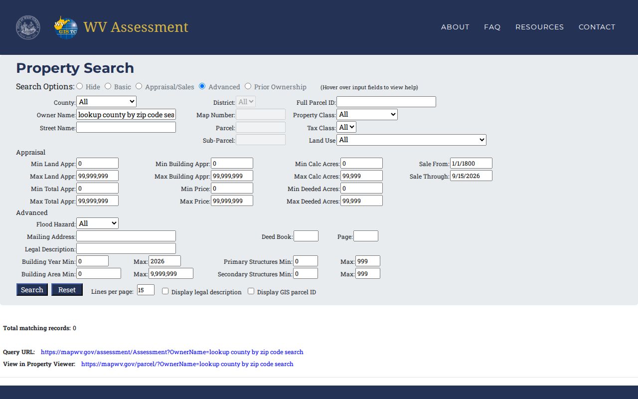
Use the form to narrow the query, then confirm any result with its parcel key and record date.
What a Raleigh County Property Record Shows
One Raleigh County assessment result shows how a simple search row can open into a fuller parcel card. The owner of record here is the "97 STANLEY STREET TRUST BECKLEY WEST VIRGINIA." The property address reads "97 STANLEY ST," and the record sits in County 41-Raleigh, District 1-Beckley Corp.
| Current Owner | 97 STANLEY STREET TRUST BECKLEY WEST VIRGINIA |
|---|---|
| Property Address | 97 STANLEY ST, the situs shown in the sample |
| County / District | 41-Raleigh / 1-Beckley Corp |
| Map / Parcel | 17 / 190.0; preserve the exact display |
| Root Parcel ID | 41010017019000000000 |
| Area / Flood | 0.13 deeded acres / code FT |
| Appraisals | Building $32,300; land $9,000; total $41,300 |
| Other detail | Last sale, mailing address, exemption, sketch, and value history were not captured. |
Result labels identify the record. They do not show every prior owner. They also skip current occupants, open liens, and survey boundaries. Last-sale detail, mailing address, exemption, building sketch, and value history live in the parcel-detail view. A deed book and page search exists as an advanced field. Still, any returned reference needs the actual instrument from the Clerk.
Address and Mailing Clues in Raleigh
The Property Address field points to the parcel's physical situs. Mailing Address is a separate advanced field, and it can reveal where tax notices go. That might be a post office box. It could also be a business, a trust, an agent, or an estate. A mailing city does not prove the land sits inside that municipality. A ZIP code is not a parcel or city boundary either.
When a street query fails, vary the suffix or directional. You can also search just the street name. Then compare the district and map on the result. For rural or changed addresses, Raleigh's Building Code ordinance requires street-address verification by County EOC for applicable permits. Match that verified address against the Assessor's Property Address. Compare it also against the deed's legal description before concluding two entries describe different land.
A Broad Raleigh Owner Search Can Stop at 1,000
A broad statewide query hits a 1,000-match cap in Raleigh County. That cap limits the displayed result set only. It does not mean the county holds just that many parcels. It says nothing against omitted owners. Narrow the search by county, district, street, tax class, map, or a known parcel value. Hunting one parcel calls for an exact street or root ID rather than a long name list.
Owner-name results can mix in common names, joint owners, trusts, LLCs, and estates. Use the precise entity spelling from a prior deed or assessor result. Then compare map and legal description. For an entity, the Secretary of State works as an identity cross-check. It is not the property title record. Save the query and date. The Assessor updates its map and data over time.
Read Raleigh’s District, Map, and Parcel
Once a search finds the parcel, its tax-map key is steadier than any street spelling. West Virginia parcel data joins district, map, parcel, suffix, and special values into one ParID. One Raleigh example reads County 41-Raleigh, District 1-Beckley Corp, Map 17, Parcel 190.0. Its Root Parcel ID ran twenty digits. A printed map number is the sheet, not the parcel number. Keep each piece in separate notes. A map may show district "01" while a portal shows "1", and the sample parcel appears as "190.0." Preserve those labels exactly. The Assessor's mapping desk can help. For the legal land description, the recorded plat or deed is still the source.
Trusts, Estates, and Owner Names
Raleigh's sample record is useful because its Current Owner field names a trust. The same name search can return joint owners, an LLC, an estate, or a fiduciary. That result is a tax-roll label. It does not prove the named party lives there. A mailing address may belong to an agent or administrator. West Virginia's Address Confidentiality Program lets eligible participants use a substitute address in government transactions.
The Raleigh probate questionnaire targets a recently settled estate. It asks whether the decedent held county real estate. It also asks the assessed value and the street address. And it asks whether the land was jointly owned. So the tax ticket is a strong locate clue. The recorded fiduciary deed or other transfer must still be checked with the Clerk. The statewide business portal's exact search route is uncertain here. Skip the guessing. Use official Secretary of State channels only.
From Raleigh Search Result to Deed
The Assessor is not the deed record. Carry the owner, map and parcel, legal description, or deed-book and page clue to the Raleigh County Clerk. Search the present owner as grantee. Inspect the newest deed. Compare its recording reference and land description against the assessment result. A broad property search can find the likely parcel. The instrument confirms what was actually recorded.
The Clerk's online land-record directory lists deeds, deeds of trust, liens, releases, plats, assignments, and foreclosure reports. When the web index returns no match, ask the Record Room about a book, microfilm, or office lookup. The full copy and chain process sits on the Raleigh County deed records page.
Permit Files Add an Address Trail
Permits help most after the parcel is found. A rural address or a changed road name can make the map hard to read. Raleigh County's ordinance can require a tax map, parcel and lot, zoning classification, and use and setback details. It can also call for boundaries, utility approvals, floodplain elevation, stormwater review, and address verification. Those requirements link the property search to a construction file. They do not make the permit a deed.
The county Building Code page links a Citizen Portal. No full address-indexed permit search is offered online. Ask the office for a permit, site plan, inspection, occupancy, or appeal file by address, parcel, work type, and year. Beckley, Sophia, and Mabscott keep separate municipal records. Their online access varies.
Search by Address, Owner, or Parcel
The right key depends on what you already know. A street is easy to recall, but the tax roll may spell or format it differently. An owner name can surface multiple holdings. Common names and entity owners make it messy. A parcel ID is precise once found, though its parts must be copied correctly across the assessment site, map, and deed reference.
| Search Key | Best For | Where It Works | Watch Out |
|---|---|---|---|
| Address or street | Locate a known site or road | WV Property Assessment; map viewer | Street-number behavior and ZIP search were not verified |
| Owner name | Find holdings tied to a person, trust, LLC, or estate | Assessment form; Clerk index | Common names and the 1,000-result cap need narrowing |
| Parcel ID | Carry one exact tax-map record between offices | Assessment search; GIS; Clerk reference | Preserve district, map, parcel, suffix, and leading zeros |
Not a title search. A Raleigh County property search locates tax and recorded records but does not establish clear title or find every unrecorded interest. A title examination is a separate professional task.